The Jiva Nal is the least known of the four streams of the GHNP. It drains the extreme north-west corner of the Park, emanating from the mountains and glaciers that guard its northern frontiers, and after covering about 65 kms, meets the Sainj at Siund. The trek to its source and back takes seven days. Given the pristine purity of its catchment and the wealth of wildlife there, the Park management does not encourage treks there, and very few trekkers get to see the hidden wonders of the valley of the Jiva Nal.
The journey, for those who are fortunate enough to obtain permission for it, begins in the Sainj valley from Neulli (the road-head), on to Shakti (first camp-site, 2100 m), a pleasant trek of 22 kms. all along and up the river. Here one leaves the Sainj on its right bank and climbs for seven straight hours in a northerly direction to Satogani thatch ( 3700 m). It’s a hard slog because there is no discernible track, the lush undergrowth reaches one’s armpits, and the tree cover gradually changes from broad leaves to conifers and then to the kharsu oak and hill bamboo, known as “nirgal.” The world changes, however, once the ridge line is attained and the panorama of Satogani thatch lies spread out before one’s unbelieving eyes like a carpet of a million hues. It’s a four kilometer long meadow that would humble the tulip gardens of Srinagar: a carpet of geraniums, poppies, primulas, geums, the cobra plant and the imperial brahm kamal, the favourite flower of the goddess Parvati. Co-existing with them was the whole gamut of rare medicinal herbs: dhoop, karu, patish, hathpanja. In all my years of trekking I have never seen such fecundity of plant life; it’s a testimony to the rejuvenating powers of nature once the heavy hand of Man is removed.
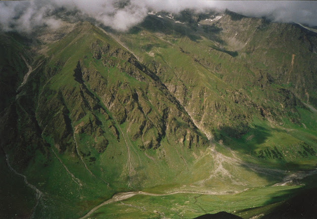
The third day’s trek, also about seven hours but not so strenuous, brought us first to the Satogani pass (4300 m), which is the watershed between the Sainj and Jiva Nal valleys, and then steeply down to the Sartu camp-site at 3700 meters. Sartu is a flat meadow on a shelf above the left bank of the Jiva: to the north is the 18000 feet high Khandedar massif, beyond which is the Parbati valley. The eastern end is closed in by even higher, 20000 feet ranges, and behind them lies Spiti. It is in the snow plains and glaciers of these mountains that the Jiva Nal takes birth, winding its way down those smooth white slopes like a necklace on the alabaster bosom of a Nordic beauty. There are massive brown bears here, and ghoral, Himalayan tahr and snow leopard, but we did not see any.
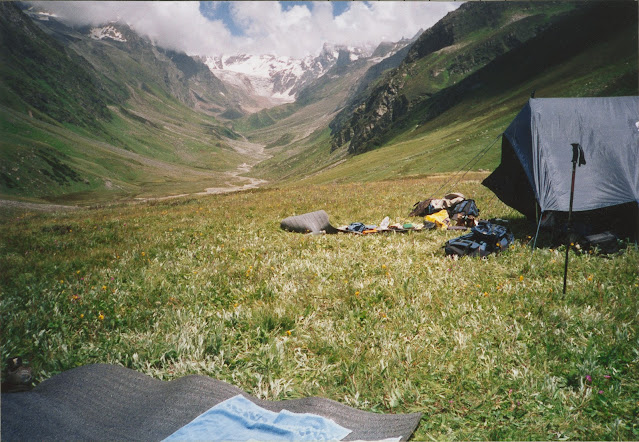
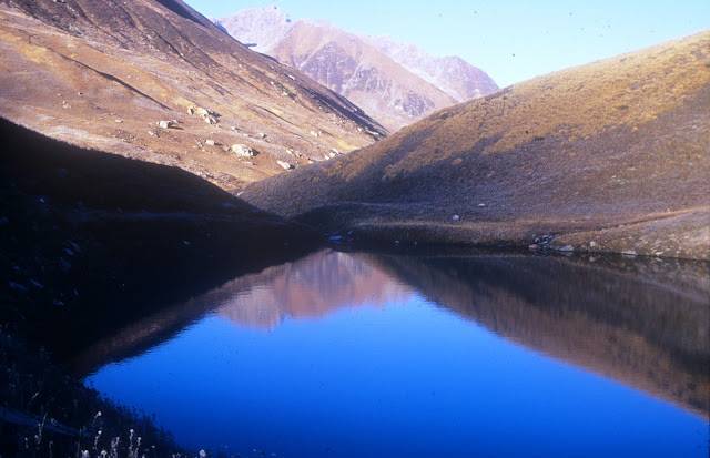
So captivating was the landscape that we spent two days here, though we did not press further upstream for lack of time. On the fifth morning we rose early to cross over to the right bank of the Jiva Nal before the snow melt made the stream impassable. The track now veers left, to the west, following the Jiva downstream, past the iridescent blue wonder that is the Sartu glacial pond. There are spectacular snow-bridges and waterfalls on the way. Emily, a French girl who was part of our party, fell while photographing a waterfall: we immediately named that cascade “ Emily Falls” and it is now so recorded in the GHNP maps! So now you know how natural features are named! After ten kms. one arrives at Duada (literally, “where two roads meet”). A major gorge meets the Jiva from the north at this point- the Duada khad- and there is an impossibly steep trekking trail up this khad which goes to Phanchi Gallu (4664 meters). The GHNP ends at that point, beyond which is the Parbati valley. (I was keen to do this trek someday but could not find the time; but my good friend Sanjeeva Pandey has done it, and his knees are now paying the price for that!). In 2010 the HP govt. established a new national park called Kheer Ganga NP and the entire area beyond Phanchi Gallu is included in it, forming a seamless natural reserve right up to the Pin Parbat pass. This is one of the rare things the govt. got right!
Duada is a clearing next to the river, hemmed in by thick forests. There is no habitation here, just a broken down, unused forest hut and a large grassy mound- this knoll has a grim but fascinating myth attached to it. According to legend there was a thriving village here a couple of centuries ago. The local Devta allowed the people to live here on the condition that they would not kill the animals or birds in the forests. After a few years the villagers broke this covenant and started slaughtering the wildlife. The furious deity emerged from the jungle one night, big as a deodar tree, pulled down all the houses and killed each and every human there. The mound is all that remains of the village, and no one has dared to settle there again. The locals will not stop here even for a cup of tea, so deep is the myth embedded in their cultural past.
The legend may or may not be true but there can be no doubt that the devtas reign supreme in these remote regions. Organised religion has minimal influence here, thankfully, for the devtas are a force for conservation . Each village has a devsthan or sacred grove from where even a twig cannot be removed. The Duada devta has forbidden meat or eggs from entering his domain, and we had to send back our store of these! (Fortunately, there was no bar on the demon rum, which would have been a deal breaker!) I have observed this conservationist streak in the near animalistic beliefs throughout the remoter areas of the state and can only humbly thank these nameless deities for their role in protecting the natural environment.
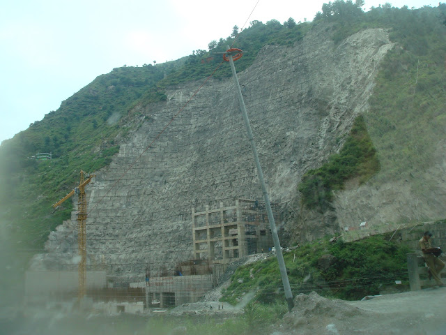
One crosses to the left bank of the Jiva below Duada and now leaves the stream to ascend to Subli (3400 m.), the day’s campsite. This is the primeval habitat of the western tragopan and at dawn the next day we could hear their calls all around us but, sadly, did not make any sighting. The sixth day’s journey is not very exciting: an hour’s trekking brings one to the Kandi Gallu pass (3700 m.), at which point we descended again into the Sainj valley. By evening we reached habitation again- the little village of Bhagikashahri, where we spent the night in a school compound. The next day it is a four hour, 12 km. hike back and down to Neulli and the Sainj river: we had completed a full circle in seven days. The Jiva Nal itself meets the Sainj 10 kms. further downstream at Siund, but it is dead long before that. Its waters have now been trapped somewhere below Duada and diverted into underground tunnels to power the turbines of the Phase I of the Parbati Project(800 MW). This power house is in Siund, whose greenery has now become one solid mass of concrete, rewriting the geology of the area, with disastrous consequences, as we witnessed in July and August this year.
The gods of commerce have arrived in this remote and pristine region to stay. But I much preferred the devta of Duada.
| The author retired from the IAS in December 2010. A keen environmentalist and trekker he has published a book on high altitude trekking in the Himachal Himalayas: THE TRAILS LESS TRAVELLED.
His second book- SPECTRE OF CHOOR DHAR is a collection of short stories based in Himachal that was published in July 2019. His third book was released in August 2020: POLYTICKS, DEMOCKRAZY AND MUMBO JUMBO is a compilation of satirical and humorous articles on the state of our nation. His fourth book was published in July 2021. INDIA: THE WASTED YEARS – chronicles all the missed opportunities in the last nine years. His fifth book – THE DEPUTY COMMISSIONER’S DOG AND OTHER COLLEAGUES – released in September 2023, portrays the lighter side of life in the IAS and in Himachal. He published his sixth book, DISAPPEARING DEMOCRACY-DISMANTLING OF A NATION in March 2024; it is a commentary on events from 2021 to the present, a sequel to THE WASTED YEARS. Shukla writes for various publications and websites on the environment, governance and social issues. He divides his time between Delhi and his cottage in a small village above Shimla. He blogs at avayshukla.blogspot.com |
