After the Partition of India in 1947, a search began for a new capital for East Punjab. Lahore, the capital of undivided Punjab, had been allocated to Pakistan as the capital of West Punjab. To select a suitable site for Punjab’s capital in India, the state government appointed a committee under the chairmanship of P.L. Varma in 1948. After a thorough survey, the committee compiled a list of existing towns, but these were rejected for various reasons, including water shortages, defence vulnerabilities, or inaccessibility. The committee concluded that these towns, overwhelmed by the massive influx of refugees, could not meet the needs of a state capital. Ultimately, it was decided to build a new capital city on an open site.
After evaluating several possibilities, a team of experts selected the current site, located in the sub-mountainous region 260 kilometres north of Delhi. This location was deemed ideal due to its central position in the undivided state of Punjab, its proximity to the national capital, the availability of sufficient water, and its natural gradient for drainage. With the Shivalik Hills as a backdrop, the site offered immense potential for imaginative landscaping and stunning views.
Chandigarh, named after a temple, dedicated to the Hindu goddess Chandi, has become one of the 20th century’s boldest experiments in architecture and urban planning.
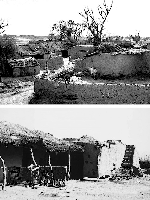
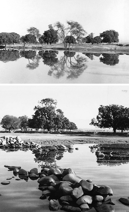
The original site consisted primarily of sprawling farmlands and rainwater ponds, dotted with groves of mango, peepal, banyan, kikar, jamun, and sheesham trees, and encompassing 28 villages. It was bounded by two seasonal rivulets—the Patiali-ki-Rao in the northwest and the Sukhna Choe in the southeast—with altitudes ranging from 305 to 365 meters above sea level.
A team led by Albert Mayer, a planner from the American firm Mayer, Whittlesey and Glass, and Matthew Nowicki, a brilliant Polish architect, was initially selected to design the new capital. They prepared the first plan in 1949. Tragically, Nowicki died in a plane crash in 1950, leaving Mayer heartbroken and unwilling to continue. It led to the appointment of a new team. In November 1950, a committee comprising State Administrator P.N. Thapar and Chief Engineer P.L. Varma chose the Paris-based Swiss architect Le Corbusier, his cousin Pierre Jeanneret, and the British couple Maxwell Fry and Jane Drew to design the city.
Land acquisition began in 1950, and construction started in 1951. The result was the “City Beautiful,” Chandigarh—a source of pride not only for its residents but for the entire state of Punjab and, indeed, the country. As anticipated, it accommodated a large influx of refugees from West Punjab (now Pakistan).
Countless books and articles worldwide have celebrated the success of this urban experiment. Yet, scant literature exists on the plight of the thousands of inhabitants from the 28 villages uprooted to make way for Chandigarh.
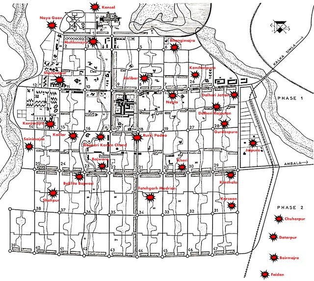
The first phase of land acquisition and village displacement began in 1950, affecting 17 villages. These included Bhangimajra, Nagla, Shahjadpur, Sainimajra, Kanjimajra, Kalibar, Kaillar, Mehlemajra, Rurki Padao, Kheri, Kanchanpura, Gurdaspura, Bajwari Karam Chand, Dalheri Rajputan, and Dalheri Jattan. Additionally, land from the villages of Kansal and Naya Gaon was acquired, but their inhabited areas were spared from demolition.
The second phase, starting in 1960, uprooted 11 more villages: Shahpur, Kanthala, Fatehgarh Madrian, Karsaan, Bajwara, Datarpur, Faidan, Bairmajra, Jaipura, Chuharpur, and Bakhta Bajwari.
The Acquired Land: Fertility and Features
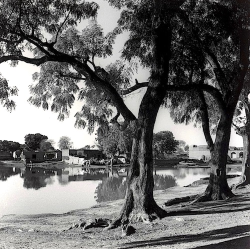
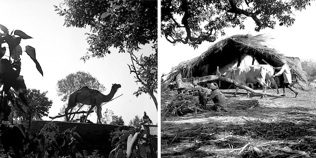
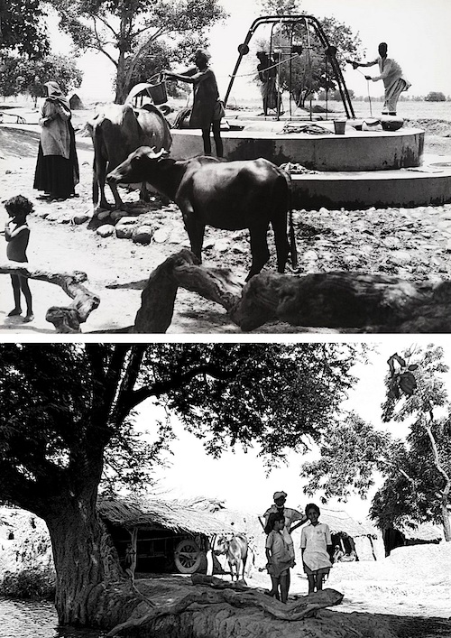
The 28,000 acres of land from these villages spanned 36 square kilometres in a transitional zone between the flat alluvial Punjab Plains and the rugged Shivalik Hills. Over 80 per cent of the acquired land was cultivable, supporting crops such as wheat, maize, mustard, cotton, pulses, sugarcane, and groundnuts. The undulating farmlands were interspersed with groves of mango, guava, peepal, banyan, kikar, jamun, and sheesham trees. Common village lands, known as shamlats, included pastures, playfields, fairgrounds, ponds (tobas), and burial grounds. The region depended on groundwater and monsoon-fed choes for water, with Persian wheels and hand-dug wells serving as key irrigation tools.
Ecologically, this was more than just farmland; it was a biodiversity hotspot in the Western Himalayan ecoregion, where subtropical dry forests met wetlands. Towering peepal, khair, neem, and banyan trees formed semi-arid scrubs and deciduous groves. Wildlife thrived here: nilgai and blackbuck grazed alongside leopards, while peafowl, sarus cranes, and migratory waterfowl echoed through the air. Reptiles like tortoises and snakes navigated the underbrush, and frogs chorused from the ponds, supporting networks of insects and small mammals. Domestic herds of cattle, horses, and camels coexisted with their wild counterparts. As a crucial corridor between the plains and the Shivalik Hills, the area mitigated erosion and flooding, with its wetlands absorbing much of the monsoon rains from July to September. It was not just a source of sustenance but a complete livelihood ecosystem, from beekeeping amid the blooms to fishing in the streams.
The phased acquisition (1950–1972) bulldozed this vibrant landscape into a rigid grid of sector modules, favouring urban efficiency over ecological balance.
Life and Harmony in Puadh’s Displaced Villages
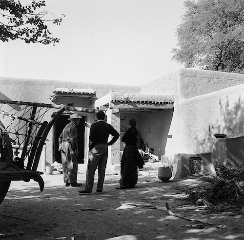
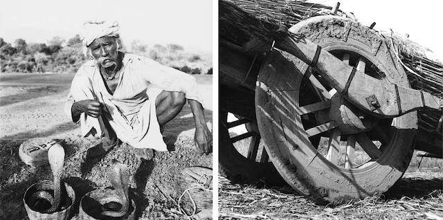
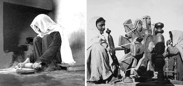
The 28 villages displaced for Chandigarh’s construction were quintessential rural settlements in the Puadh region of Punjab—a fertile sub-region at the foothills of the Shivalik Hills. Before the 1950s, these villages embodied a self-sustaining agrarian lifestyle shaped by seasonal cycles, communal bonds, and a blend of Sikh, Hindu, and Muslim influences.
Daily life revolved around the rhythms of agriculture, with monsoons guiding the planting and harvesting of rabi (winter) and kharif (summer) crops. Mornings started with the creak of Persian wheels irrigating fields, followed by bullock carts carrying families to orchards or grazing lands. Women tended households, grinding grain on chakki stones, drawing water from tobas, and preparing meals. Evenings featured communal gatherings at kheras (memorial groves) or dharamsalas (rest houses), where elders shared stories under ancient peepal trees, and children played gulli-danda or listened to folk songs.
These uprooted Puadh villages exemplified harmonious coexistence through economic interdependence and shared spaces, though stratified by caste and faith. In essence, they thrived on a delicate balance of toil and togetherness, where social interaction and sharing defined community identity.
Plight of Chandigarh’s Displaced Villagers
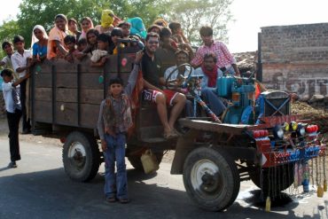
The displacement of these 28 villages was a profound tragedy. What began as a “dreamy time” of national unity in the wake of Partition descended into forced evictions, inadequate compensation, and cultural erasure. Protests were met with arrests, and while a Resettlement Act was enacted, it provided meagre “land-for-land” exchanges for Phase 1 (17 villages) but none for Phase 2 (11 villages). Heritage sites—orchards, wells, gurdwaras—were demolished without recompense, leaving villagers as “homeless migrants in their own country.” The uprooting shattered a self-sustaining agrarian world, triggering immediate chaos (such as loading belongings onto bullock carts amid wailing women) that cascaded into lifelong scars.
The merciless demolition inflicted trauma from watching homes collapse, and ancestral ties sever; a sense of identity as “sons of the soil” gave way to estrangement. Children, bewildered, asked, “Why and where are we moving?” amid scenes reminiscent of Partition. Abrupt evictions rendered families homeless, forcing them to trek with their possessions; abandoned “hungry cattle” and orchards contributed to malnutrition. Traditional occupations, such as farming and artisanal trades, vanished without viable alternatives. Community relationships were fractured, dissolving the multi-faith harmony that once flourished through daily interactions. Artisans lost their patronage, halting home-based industries. The uprooted villagers endured costly, protracted litigations that persist even after 75 years. This saga highlights the human cost of development: While Chandigarh flourishes as a “beautiful city,” its foundations rest on unhealed wounds.
Decline of the Puadhi Dialect
The Puadhi dialect, a subdialect of Eastern Punjabi, is native to the Puadh region—a historic agrarian belt between the Sutlej and Ghaggar rivers. Marked by soft vowels, earthy idioms, and influences from Haryanvi, Pahari, and standard Punjabi, it historically enriched folk traditions such as Kavishri ballads and unique bhangra variants. It thrived in the 28+ villages displaced for Chandigarh’s construction. Before displacement, Puadhi was the vibrant medium of daily life, festivals, and community bonds in these Puadhi-speaking hamlets, nurturing a distinct cultural identity amid the harmony of multiple faiths.
However, the forced migration of 10,000–15,000 residents—scattered to resettlements in places like Panchkula, Mani Majra, or distant Punjab fringes—sparked a rapid decline, rendering Puadhi “almost extinct” by the 21st century.
Mapping Chandigarh to Displaced Villages
The Chandigarh Master Plan, implemented from 1952 under Le Corbusier’s design, transformed 28,000 acres of fertile Punjab land into a gridded urban utopia, erasing 28 villages in two phases: 17 in Phase 1 (1950–1960) and 11 in Phase 2 (1960–1972). This relentless destruction buried ancestral homes, community buildings, religious sites, orchards, and commons beneath sectors and landmarks, often without a trace. While exact boundaries overlap due to phased acquisitions, historical records, oral accounts, and maps connect specific sites to the villages. Based on available information, a comprehensive layout plan of Chandigarh has been prepared, illustrating the locations of the villages that were relocated. It is hoped that inquisitive readers can easily comprehend it.
Neglected Legacy of the Displaced
The “think tank” behind Chandigarh—comprising architects and Indian officials under Prime Minister Jawaharlal Nehru—envisioned the city as a post-independence symbol of modernity and national unity. Hastily conceived between 1947 and 1952 to replace Lahore (lost to Pakistan) as Punjab’s capital, the project was driven by Partition’s chaos, which displaced 15 million people and claimed 1 million lives. This urgency prioritized rapid reconstruction for incoming refugees from West Punjab over the concerns of the 28 uprooted Puadh villages. The result was a profound disconnect: heritage elements, such as villages, orchards, kheras (memorial groves), and the Puadhi dialect, vanished beneath the sectors, unpreserved due to ideological and practical oversights.
The dislocated villagers have long demanded that their lost legacy be sensitively preserved—perhaps through a dedicated museum, along with commemorative plaques at strategic points and locations where the villages were uprooted, and near preserved landmarks like historic trees or religious sites.
In short, while the original planners’ oversights reflected the blind spots of their era, a museum today could rectify this—honouring the Puadhi refugees as co-founders of Chandigarh, not mere footnotes. It is time to safeguard their history, customs, and inheritance for posterity.
- All photos are by unknown photographers and are in the public domain.
Sarbjit Bahga (b1957) is a Chandigarh-based architect, author, photo artist, and archivist. He is the Principal Architect of Bahga Design Studio LLP. Earlier, Bahga worked in the Department of Architecture, Punjab, Punjab Health Systems Corporation, and Punjab Mandi Board in various positions.
He has more than 42 years of practical experience designing various types of buildings, complexes, and large campuses. His completed works include an eclectic range of administrative, recreational, educational, medical, residential, commercial, and agricultural buildings. A monograph on his selected works titled “MODERN REGIONALISM: The Architecture of Sarbjit Bahga” has been published.
Bahga is also a keen researcher and a prolific architectural writer. He has 12 books to his credit, which include Modern Architecture in India, New Indian Homes, Le Corbusier, and Pierre Jeanneret: The Indian Architecture, Trees in Urban Habitat, Landscaping Human Habitat, New Indian Architecture -1947-2020, and Hand-Drawn Perspectives and Sketches. Bahga’s contribution to architecture has been largely recognized. He is a three-time recipient of the World Architecture Community Awards. His name has been featured in the Guinness Book of World Records for designing the “longest covered concrete corridor” in Vidya Sagar Institute of Mental Health, Amritsar.
Thank you Sarbjot sir for sharing the unsettling history of Chandigarh’s existence at the cost of erasing 28 Puadhi speaking villages. Although the story is quite heart-breaking, it reminds of the popular saying – no pain no gain. Now Punjab is known for its capital city and its benefits to the entire north Indian population. We must honour the Puadhi speaking key people and let the youth more about the Puadhi culture on Chandigarh creation day.