Aim of the article: To remember the 1905 Kangra earthquake and share basic, layman-friendly information with audiences in the region of Himachal Pradesh, based on the research paper by Walter Szeliga and Roger Bilham (2017).
The Kangra earthquake remains one of the most devastating seismic events in Himalayan earthquake history. Striking in 1905—over a century ago—it caused the destruction of around 1,00,000 homes and claimed more than 20,000 lives (Middlemiss, 1905, 1910), with an economic cost of nearly 2.9 million rupees at the time. What makes this earthquake particularly significant is that it occurred during the early phase of instrumental seismology, making it one of the earliest large earthquakes to be scientifically recorded and studied. While Gutenberg and Richter initially reported the magnitude as Ms 8, more recent studies suggest a revised estimate closer to Mw 7.8. A systematic and incredibly detailed field investigation was conducted by Charles Middlemiss between 1905 and 1910, during which he walked through the most affected regions—covering approximately 587 km—documenting how buildings collapsed, analysing structural failures, and using the Rossi–Forel intensity scale to create isoseismal maps. His work was published in the Memoirs of the Geological Survey of India. Interestingly, places Middlemiss never visited were described in an Urdu account written by Baduwi in 1905. Decades later, researchers such as Ambraseys and Douglas (2004) and Martin and Szeliga (2010) revisited the intensity data and converted it into MSK and EMS scales, enhancing our modern understanding of this historic event.
Geologically, the rupture mechanism of the Kangra earthquake remains debated. Some researchers attribute it to an active strike-slip fault—the Kangra Valley Fault (KVF) (Malik et al. 2015)—while others argue that it was primarily a thrust event related to the Main Himalayan Thrust (MHT), which typically governs large earthquakes across the Himalayan arc. Given the oblique convergence between the Indian and Eurasian plates, it is likely that both thrust and strike-slip motions were involved. So how much of the fault actually ruptured? Field evidence and GPS measurements further suggest that the rupture did not extend southward beyond the Jawalamukhi thrust, providing a boundary for the subsurface slip. This understanding of the rupture extent has significantly evolved, especially through comparison with more recent earthquakes.
Our present understanding of the Kangra event has been enriched by comparing it to the 2015 Mw 7.8 Gorkha earthquake in Nepal, as both shared key characteristics—neither ruptured the frontal thrusts and both triggered aftershocks over 120 km away. In the Kangra case, a notable 1906 aftershock occurred southeast of Dharamshala, near Shimla. Based on more recent geodetic analyses, the rupture length of the Kangra earthquake is now estimated to range between 100 and 190 km.
The question of whether Kangra-type earthquakes reoccur—and how often—is a highly debated one. If the 1905 earthquake had an average slip of just 1.1 meters, similar events would be expected approximately every 100 years, given a convergence rate of about 15 mm/year. However, since no similar event has been recorded in over 300 years, it’s likely that the actual slip was greater—around 2.3 meters—which would imply a recurrence interval of 150–200 years, or even longer if the slip reached up to 5 meters. Evidence from temples like the Bishweshwar Mahadev Temple at Bajaura, which survived the 1905 quake with only minor damage, indicates that earlier, more powerful earthquakes may have occurred in the region. This suggests that the 1905 quake may not have been the largest possible. With Indo-Tibetan convergence continuing to build tectonic stress, and a current slip deficit estimated between 1.5 and 1.7 meters, there is a growing need to reflect on the seismic risks still facing the region.
When we consider recent global events—such as the devastating Turkey and Myanmar earthquakes—it becomes clear that more than 100 earthquakes above Mw 6 occur worldwide every year. For instance, the recent M7.7 Myanmar earthquake 2025, along the Sagaing strike-slip fault had a USGS-estimated 67% probability of more than 10,000 fatalities. One special feature of that event was the occurrence of supershear rupture—where the rupture travels faster than the seismic waves it produces—which caused damage even 1,000 km away, such as in high-rise buildings in Bangkok. Supershear events are particularly dangerous because they can amplify the destruction over wide areas.
Studying historical events, updating seismic hazard models, and integrating paleoseismic and GPS data are crucial steps for future preparedness. Constructing buildings that follow earthquake-resistant codes will make a significant difference. This only reinforces the importance of remembering and learning from the Kangra 1905 earthquake. At the end of the day, while geologists cannot predict exactly when the next big earthquake will strike, what truly matters is preparedness, awareness, and sustainable development—because earthquakes will come, and it’s our readiness that determines how much damage they leave behind.
Sources: –
- New Constraints on the Mechanism and Rupture Area for the 1905 Mw 7.8 Kangra Earthquake, Northwest Himalaya by Walter Szeliga and Roger Bilham-2017
- Judith Hubbard, co-creator of the Earthquake Insights newsletter and an earthquake scientist at Cornell University in Ithaca, New York.)
Glossary: –
Ms (Surface-Wave Magnitude): An older scale that measures earthquake size using surface waves. Used historically but not very accurate for very large earthquakes.
Mw (Moment Magnitude): The modern and most reliable scale. It measures the total energy released during an earthquake and is used worldwide today.
RF (Rossi–Forel) Scale: An early earthquake intensity scale based on how people felt the shaking and the visible damage. Used by Middlemiss in 1905.
MSK Scale: A damage-based scale used to classify the strength of shaking during earthquakes, especially in India and Europe.
EMS Scale: A modern version of the MSK scale, giving more detailed descriptions of building damage and human experiences during an earthquake.
Supershear Rupture: A rare type of earthquake where the fault breaks faster than the seismic waves, causing stronger shaking over large distances.
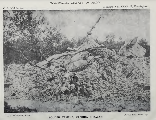
Figure 1 Photograph of the destroyed Golden Temple, Kangra Bhawan, taken after the 1905 Kangra earthquake. This image, captured by Charles S. Middlemiss and published as the frontispiece of Memoirs, Vol. XXXVIII of the Geological Survey of India.
Authors: – Shubham Choudhary and Shailza Choudhary

Shubham Chaudhary is a geologist. He teaches geology to undergraduates at a government college in Himachal Pradesh. He lives in Shimla.
