(This is the second of four blogs on the GHNP)
The Sainj is the second of the four enchanting mountain streams in the Great Himalayan National Park – GHNP (counting from the east), draining its central parts. Most people do not go beyond its confluence with the Tirthan at Larji village, about 35 kilometres below Kullu, and miss out on a fascinating experience- the journey to its source, the Rakti-Sar glacier at 4000 metres. One can approach it from either the east, crossing from the Tirthan at Rolla, over the ridge line at Guntarao and Rakhundi Top (3600 meters), on to Dhela thatch (3200 meters) down to the Sainj river near Shakti village, and then follow the river upwards. This would, however, make the trek very demanding and long (seven days to the glacial source of the river), so most people prefer the second route, up the Sainj valley itself rather than doing the transverse from the Tirthan.
This five day trek begins at a tiny hamlet called Neulli, the last roadhead in the Sainj valley, 45 kms from the traffic tunnel on the Mandi-Manali national Highway, on the left bank of the Beas. Neulli is reached after driving through the larger villages of Sainj and Siund, but the less said about them the better: both have been devastated by the construction of the Parbati Hydel project and their natural environment ruined for perpetuity. Neulli itself is now meeting the same fate: just beyond it is the 100 MW Sainj Hydel project. This falls within the eco-zone of the GHNP which is supposed to be a protected area. This project should never have been allowed but then this is the sad tale of Himachal’s “development” in microcosm, and it’s not the only one.
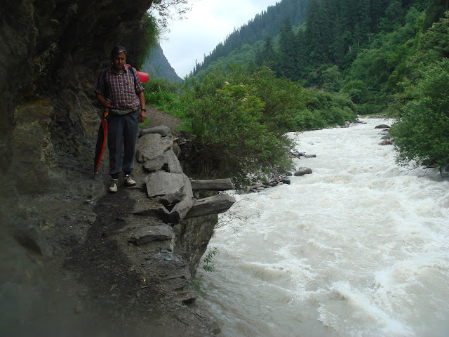
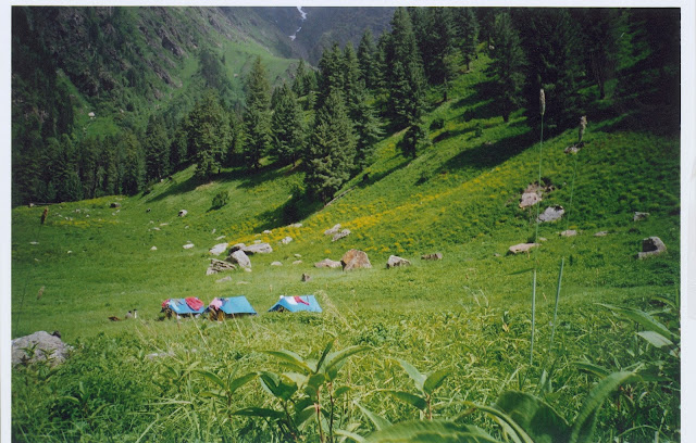
The journey on foot begins from Neulli and gradually, as one passes the sylvan little hamlets of Niharni, Denga and Chenga, one’s anger and frustration begins to fade, soothed by the sheer beauty and serenity of the river, the thick forests that embrace it lovingly on both sides, the sheer exuberance of the rare birds that live off the river- the brown dipper, the plumbeous red-start, and the blue whistling thrush. It is a captivating, 22 km trek all along the Sainj to the first day’s night halt at the forest department trekker’s camp at Shakti, a small village of about 25 families. Located on the right bank amid a thick grove of seabuck thorn, the camp has dormitories, kitchen, toilets with running water and can easily accommodate about 20 persons. From here on, however, it will be tents, sleeping bags, dal-roti and “siddu”- washed down, quite appropriately, with the old monk’s libation since this is a near-pilgrimage after all !
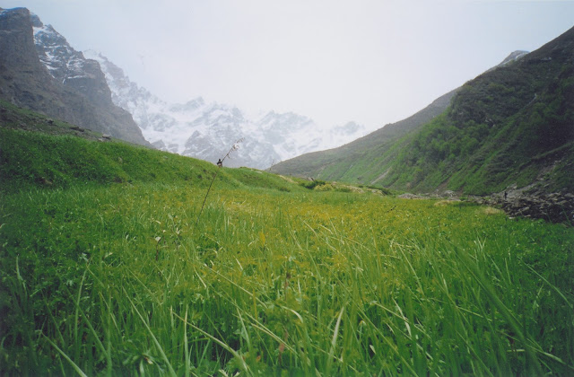
On the second day one crosses the Sainj to its left bank on a swanky new wooden bridge (the old one was washed away by a flood some years ago) and proceeds upstream for eight kms. to the hamlet of Marour, the last habitation, consisting of about twenty houses and an ancient temple. There used to be a forest rest house here but about twenty years ago it caught fire mysteriously one winter night- the suspected handiwork of the Marourians who wished to discourage touring by the foresters in the area: the former are suspected to be indulging in large scale poaching and extraction of rare medicinal plants from the Park. (The rest house has since been rebuilt). It is ten kms. and three hours of gruelling trekking from here to Parkatchi thatch, the next camping site. There are two tracks from here, one along the river and the other five hundred feet higher up, through the forests; both are equally strenuous, but on the former one can pick up some amazing driftwood! Just before Parkatchi we crossed a substantial stream coming from the north-east and joining the Sainj; this is the Chiush Nallah, and beyond this is all Park territory. Parkatchi thatch ( 2950 metres) is a flat bluff projecting into the river valley and about 300 feet above it. The size of four football fields, it was a sight to behold: completely carpeted with yellow euphorbia, blue geraniums, red primula and purple ratanjots, a medley of colours no human artist can ever replicate. To the north rises the round summit of Munda Tapra, 6000 metres high, beyond which lie the ranges of Rampur in Shimla district. There is a one room forest hut here but we preferred to camp amongst the flowers- where else?!- and slept to the ever present, wafting aroma of the myriad of flowers, and the soothing lullaby of an adolescent, gurgling Sainj, as yet unaware of the fate that awaited it at the hands of man a few kilometers downstream.
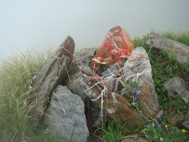
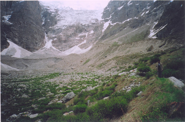
The third day’s goal is the Rakti Sar glacier itself, seven kms away though lush alpine pastures with abundant signs of bear, tragopan, monal and “maitu” ( blue sheep) all around us, enough cause for elation. About two kms. from the campsite another stream from the north joins the Sainj at a spot called Rakti-Kol; there is a small collection of rocks here, a cairn dedicated to the local Devi. A quick genuflection to the goddess here is advisable. The river turns sharply to the left and soon towering, snow covered peaks begin rising above the pasture, 17000 feet high, completely shutting out the head of the valley. Another couple of kms and we could now clearly see the massive snout of the glacier, forty feet high, almost black with moraine. Two slender streams emerged from it and joined to become the infant Sainj. The ethereal magnificence of the landscape is difficult to express in words and even a camera can capture but a hint of it. The locals consider the stream on the right as the real Sainj and have a built a pretty little “jogni” there, a-flutter with colourful flags, which can be approached only on bare feet.
We said our prayers there even as it began to snow. A big brown bear suddenly appeared on the glacier snout, reared up on its massive hind legs, peered at us short sightedly, didn’t like what it saw, and made off up the glacier at a good clip!
There is an enchanting myth attached to Rakti Sar, which translates as “head covered with blood”. Folklore has it that a demon named Raktibeej used to rule this place. He had obtained a “vardan” or blessing from the gods that made him immortal- each time a drop of his blood fell on the ground it would spawn a new Raktibeej. Secure in this invulnerability, he started terrorising the people and other gods, till they all appealed to Mahakali to do something. The Devi did battle with him: she caught him with two hands, chopped off his head with the third, and collected the flowing blood with a vessel held in her fourth hand. Thus was the demon vanquished, and to prove it, our local guides took us to a spot where the stream had turned a brownish colour- due to the blood of Raktibeej, they claimed ! It was probably a bit of copper ore but who were we to quarrel with a fable sanctified by the ages ? Nor did we want to, for this was the realm of nature and myth, not science; it commanded reverence, not scepticism. We were simply grateful for having been allowed to enter this timeless world for a few moments. Humbled by the mythology of the ages and the grim magnificence of nature, we made our way back before the snowfall turned into a blizzard. No one spoke for a long while -when God speaks, one can only listen.
| The author retired from the IAS in December 2010. A keen environmentalist and trekker he has published a book on high altitude trekking in the Himachal Himalayas: THE TRAILS LESS TRAVELLED.
His second book- SPECTRE OF CHOOR DHAR is a collection of short stories based in Himachal that was published in July 2019. His third book was released in August 2020: POLYTICKS, DEMOCKRAZY AND MUMBO JUMBO is a compilation of satirical and humorous articles on the state of our nation. His fourth book was published in July 2021. INDIA: THE WASTED YEARS – chronicles all the missed opportunities in the last nine years. His fifth book – THE DEPUTY COMMISSIONER’S DOG AND OTHER COLLEAGUES – released in September 2023, portrays the lighter side of life in the IAS and in Himachal. He published his sixth book, DISAPPEARING DEMOCRACY-DISMANTLING OF A NATION in March 2024; it is a commentary on events from 2021 to the present, a sequel to THE WASTED YEARS. Shukla writes for various publications and websites on the environment, governance and social issues. He divides his time between Delhi and his cottage in a small village above Shimla. He blogs at avayshukla.blogspot.com |