If there is one jewel in the crown of Himachal, it has to be the the Great Himalayan National Park (GHNP) in Kullu, spread over 750 sq.kms. of forested valleys, gushing mountain streams and snow covered mountains: it is also a UNESCO World Heritage site. It is a superlative repository of Himalayan flora and fauna, a trekker’s Valhalla, one of the last undisturbed areas of the state. It is drained by four magical streams, all originating from glaciers or glacial lakes-starting from the east, the Tirthan, Sainj, Jiwanal and Parbati. Trekking to the mystical sources of these rivers is a once in a life time experience, and for the true nature-lover akin to a spiritual experience, the “char dham” of a naturalistic religion, as it were! I have been fortunate to have completed this circuit and would like to share a brief account of it with those readers who may want to learn more, or even plan to go to the GHNP. This is the first of four blogs.
The Tirthan
The Tirthan is a typical mountain stream and one of the very few left in the state where the trout still run, thanks to the fact that most of its length is protected as it runs through the Park, and a later govt. decision also banned the construction of hydel projects on its mid and lower stretches. It originates from the Tirath snowfields at 4500 meters on the eastern fringes of the Park, and after flowing through pristine forests for about 100 kms joins the Beas just below Aut on the NH 21 (Mandi-Kullu highway). It requires four days of strenuous trekking and climbing to reach the source of the river, the Tirath glacier. The nearest road-head is Gushaini in the Banjar valley on the left bank. One enters the Park boundary at Ropa (8kms) but the first day’s camp site is at Rolla, another 4 kms away. It has huts, toilets and running water but from hereon one has to carry one’s own tents, sleeping bags and provisions for cooking. The original track to the Tirath glacier was all along the right bank of the river but a flood in 2005 washed away large tracts of the route, and now one has to climb high above the river immediately after Rolla, with night halts at Nada thatch (3300 meters) and Majhauni thatch (3600 meters).
A thatch is a clearing or glade surrounded by forests where shepherds camp: originally covered with a prolific growth of the rare high altitude medicinal plants and herbs, they are nowadays grazed over by sheep whose droppings further ensure that nothing grows there except weeds and coarse grasses. This used to be the case with Nada and Majhauni also, but ever since the govt. banned the entry of sheep in the Park, these thatches have now made a remarkable come-back: when I camped there in 2010 they were completely carpeted with a rich profusion of patish, salam panja and ratanjot , the rarest of alpine herbs. Nada thatch is a particularly mesmerising place, completely surrounded by a thick growth of cedar, spruce, kharsu oak, maple and dwarf rhododendron, with an abundance of bird life- in the early dawn we were privileged to be favoured with a veritable avian orchestra by the tragopans, monals, warblers, nut crackers and minivets !
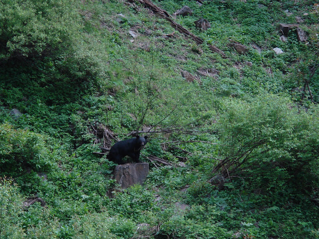
The third day’s trek- from Nada to Majhauni- takes one down to the river and then up again into the forests. Along the way we noticed plenty of leopard scat, signs of bear and a troop of langurs in a grove of taxus baccatta trees. But the climactic moment came when, just below a watercourse, we suddenly came upon a Himalayan black bear! She was sunning herself on a rock and, perhaps because of the sound of the water, did not hear our approach. We had all of three or four minutes to enjoy this amazing moment before she became aware of our presence: in an instant she sprang up, bounded across the stream, scaled a ten meter wall of rock effortlessly and vanished into the thick forest. She appeared to be pregnant and we wished her and her cub all the best- may they rule this part of paradise for ever!
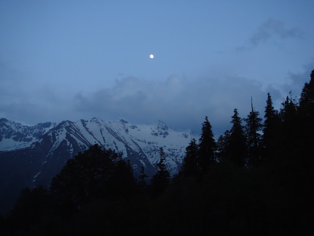
Majhauni thatch is on the right bank of the Tirthan, just above the river and very windy and cold- the Tirath glaciers are barely 8 kms. from here and the valley funnels the chilling winds straight down into the camp site. Fortunately there are three huge caves in which one can take shelter. We were now at 3600 meters, and parts of the river were covered with a thick deposit of ice- “ice bridges”, sturdy enough to walk on, but carefully, because the swift and freezing waters still flowed below them. They are useful while they last, because they provide the wild life an easy means of crossing the river. In the early morning a “kakkar”- musk deer- crossed the river on an ice bridge from the other bank, strolled through our camp site and disappeared into the undergrowth before we could photograph it !
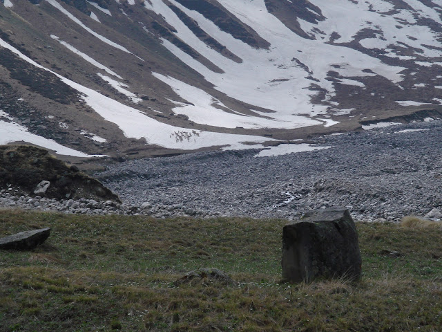
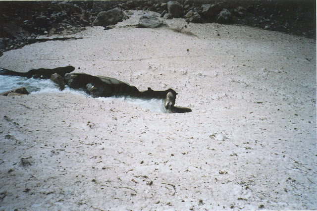
It’s a four hour trek to the Tirath glacier from the campsite, sometimes on the ice bridges and sometimes high on the right bank of the river. After six kms or so the valley broadens out into a verdant pasture 500 meters wide, completely carpeted with alpine flowers of the most amazing hues. Straight ahead, to the south and south-east are towering, snow- covered peaks and ranges, behind which lie the massive Srikhand massif and Sarahan ranges. The flanks are covered with huge glaciers: their melt- off runs down in slender black ribbons of water, converging into two primary streams which join each other on the valley floor to form the infant Tirthan. To its right, however, is a circular pool about 20 feet across, bubbling with some gas or air coming from its depths. The locals believe that this is the real source of the Tirthan and it is customary to do a “pooja” here and take a dip in the stream, notwithstanding the freezing temperatures! Our real reward, however, came a little later when the sun broke through the clouds and lit up the white mountain slopes. Lo and behold! Straight ahead we could now see two huge herds of “bharal” or blue sheep, about 60 in all, slowly going up the flanks! It was an unforgettable sight: the blue sheep are rarely sighted, such is their mountain habitat and reclusive nature. This was a double “darshan” for us- the source of the river as well as its prime custodians. We could not have asked for more, and as we wended our long way back to Majhauni we were content in the knowledge that the wildlife of GHNP was doing quite well, thank you!
| The author retired from the IAS in December 2010. A keen environmentalist and trekker he has published a book on high altitude trekking in the Himachal Himalayas: THE TRAILS LESS TRAVELLED.
His second book- SPECTRE OF CHOOR DHAR is a collection of short stories based in Himachal that was published in July 2019. His third book was released in August 2020: POLYTICKS, DEMOCKRAZY AND MUMBO JUMBO is a compilation of satirical and humorous articles on the state of our nation. His fourth book was published in July 2021. INDIA: THE WASTED YEARS – chronicles all the missed opportunities in the last nine years. His fifth book – THE DEPUTY COMMISSIONER’S DOG AND OTHER COLLEAGUES – released in September 2023, portrays the lighter side of life in the IAS and in Himachal. He published his sixth book, DISAPPEARING DEMOCRACY-DISMANTLING OF A NATION in March 2024; it is a commentary on events from 2021 to the present, a sequel to THE WASTED YEARS. Shukla writes for various publications and websites on the environment, governance and social issues. He divides his time between Delhi and his cottage in a small village above Shimla. He blogs at avayshukla.blogspot.com |

You paint a picture with your words, Avay.